Nebi Samwil
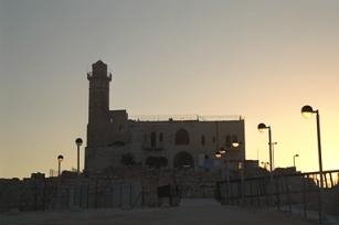
Nebi Samwil is located on a hill (908 m. above sea level), some 5 km. north of Jerusalem. The hill provides a good view of Jerusalem and controls the roads leading to the city from the north: the road from the Coastal Plain in the west and that from Samaria to the north of Jerusalem. The large mosque with a high, round minaret on the top of the hill is clearly visible from Jerusalem. It is revered by both Jews and Muslims because the cave beneath it is the traditional burial place of the prophet Samuel. Tradition associates Nebi Samwil with biblical Ramah, the burial place of the prophet Samuel. (I Samuel 25:1; 28:3) But modern studies have identified Nebi Samwil with biblical Mitzpa, a town of cultic importance in the territory of the Tribe of Benjamin. (Joshua 18:26 and Judges 21:1-8) Gedaliah son of Ahikam, who was appointed governor of Judah by the Babylonians, lived in Mitzpa and was assassinated there. (Jeremiah 41:1-10) After the return from exile, the people of Mitzpa participated in repairing the walls of Jerusalem and in the building of the Second Temple. (Nehemiah 3:7, 19)
The cultic importance of Mitzpa to the Jews during the Hellenistic period is evident from a reference in I Maccabees 3:46: They assembled at Mitzpa, opposite Jerusalem, for in former times Israel had a place of worship at Mitzpa. The proximity of Mitzpa to Jerusalem and the discovery, in the archeological excavations, of finds from the First Temple period and from Hasmonean times, lend validity to the identification of the site as the biblical Mitzpa.
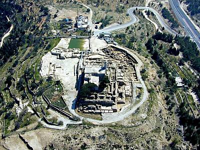
Comprehensive excavations were conducted at Nebi Samwil from 1992 to 1999. On the southeastern slopes of the site, previously unknown remains from the beginning of settlement there were found; they had not been damaged by the intensive construction activity of the Crusaders. The Crusader fortress with its fortifications and the building complex outside its walls were uncovered.
The Early Village
The first settlement, covering an estimated area of four acres, was founded at the end of the First Temple period (8th-7th centuries BCE) and continued to exist during the Persian period (6th-4th centuries BCE), as evidenced by pottery sherds and seals on handles of storage jars. Some of these are inscribed yhd, the name of the province of Judah under Persian rule. The settlement was based on agriculture: grain, grown in the broad fields in the plain to the north; olives, figs and grapes grown on the terraced hillsides. A spring on the northern slope of the hill provided water for the settlement.
During the Hellenistic period (2nd-1st centuries BCE) a large village was established under royal patronage, to protect the northern approaches to Jerusalem. The excavations uncovered the remains of several dwellings built on the hillside. The walls of the houses, some preserved to an impressive height of 4.5 m., indicate that they had two storeys. Also, a section of a 3.5 m.-wide street was exposed for a length of 55 m. A complete dwelling, on the northern side of the street, is typical of the houses of Nebi Samwil during that period. Its area was 24 x 20 m. and it consisted of rooms surrounding a courtyard. The walls were constructed of carefully trimmed stones covered with high-quality plaster and the doorposts and lintels were made of ashlars. The upper storey of the buildings was reached from the higher, northern street, while the ground floor was entered from the southern, lower street. Rock-cut cisterns guaranteed the residents' water supply.
The Byzantine Monastery
According to accounts by Hieronymous (beginning of 5th century) the bones of the prophet Samuel were brought from their place of burial in the Holy Land to the city of Chalcedon (in Asia Minor). Yet, in the same period, a monastery was built at Nebi Samwil in honor of the Prophet Samuel, which became a place of pilgrimage and served as a hostel for Christian pilgrims on their way to Jerusalem. The monastery was restored and enlarged during the reign of Justinian (mid-6th century) and it continued to exist in the Early Arab period (7th10th centuries). It was almost completely destroyed when the Crusaders built their fortress. Only a portion of mosaic pavement and a wine press remain. A very large number of Byzantine coins, some from faraway places, attest to the occupancy by pilgrims during this period.
A major pottery production center was established on the southern slope of the hill during the Early Arab period. Several pottery kilns, some with domed roofs intact, were uncovered in the excavations. Dozens of stamped jar handles with Arabic inscriptions, such as "Blessings to Yusuf" and "Blessings to Suleiman" and the name "Deir Samwil" [Monastery of Samuel] were found in the production waste pile.
The Crusader Fortress
During the Crusader period Nebi Samwil gained symbolic significance, because
from here, after a three-year journey, the Crusader army had its first
glimpse of Jerusalem (7 July 1099) . They called the hill Mons Gaudii
[Mountain of Joy] and constructed a fortress there, to protect the northern
approaches to Jerusalem from Muslim raids. Convoys of pilgrims also found
shelter within its walls on their way to the Holy City. The church within
the fortress was built in 1157 over the traditional tomb of the prophet
Samuel.
The Crusader fortress was rectangular (100 x 67 m.) surrounded by walls and with a church at its center. The stones used to build the fortress were quarried on the top of the hill, creating 5 m.-high rock-cut cliffs on the northern and eastern sides of the fortress, upon which the walls were constructed. Strong terrace-walls were built on the southern and western sides, which artificially raised the base of the fortress. The walls were some 2 m. thick, built of large ashlars reinforced with cement; a large tower (7 x 6 m.) protected the southwestern corner, a smaller one the northwestern corner of the fortress. An additional large tower (6 x 6 m.) was built on the southern side.
Two gates in its western wall gave access to the fortress. They led directly into the courtyard in which the church stood. One gate, for everyday use, was approached via a ramp next to the wall; the second one was reached over a stone bridge, 28 m. long and 2.5 m. wide. The bridge was supported by a series of arches, ascending from north to south. Along the southwestern side of the fortress two long, underground vaults were built, the southern one 72 x 8 m. and along its inner, eastern side, a 46 x 6.4 m. vault. These vaults were part of the podium upon which the courtyard was built and relieved the pressure on the retaining walls of the fortress. The spaces thereby created were used for storage.
Of the large, elaborate Crusader church, which occupied most of the fortress' courtyard, only some architectural elements, such as capitals and marble columns, were found in the excavations. A mosque, preserving portions of the earlier structure, now stands on the central part of the Crusader church. An examination beneath the mosque revealed that the traditional tomb of the prophet Samuel is the crusader crypt, which was reached by descending stairs from the church.
North of the fortress compound a large, rock-cut camping area (47 x 37 m.) was prepared for use by the crusader army, and by groups of pilgrims. It had stables with rock-cut troughs in its eastern part, and a hostel for pilgrims was built on a bedrock terrace. This compound was protected in the east by a watchtower erected on a large square base hewn out of the bedrock.
The fortress was pillaged in 1187 by the Muslims under the command of Salah ed-Din (Saladin) and was later destroyed to its foundations, for fear of falling once more into Crusader hands. A collapse of hundreds of stones, in its southeastern corner, bears witness to the destruction.
In the ensuing centuries, Nebi Samwil, as the traditional tomb of the prophet Samuel, became a place of pilgrimage for Jews, until a mosque was builtthere in 1730. It was badly damaged in 1917, during a battle between British and Turkish forces. The mosque was restored after World War I and took on its present appearance.
Remains of all periods of settlement at Nebi Samwil have been preserved at the site. Particularly impressive are the remains of the Crusader fortifications, now exposed after removal of the debris that had covered it for centuries. Above the ancient remains stands the mosque with its high minaret, a landmark clearly visible from a considerable distance.